In Marrick I turned right shortly
after entering the village instead of continuing through to the far end.
My alternative routes are:
Following the
cycle track instead of the road through Moor Row. A recommended
alternative that avoids having to cross the A595.
The Red Pike and High Stile
alternative. Enjoyable in fine weather no doubt but don't do it in rain and
mist! If you take this route then after Innominate Tarn follow a more
direct path across to the quarry clearly visible in the distance.
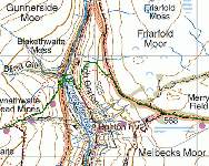
If you want to avoid the boggy ground beyond Nine
Standards then when you reach the Nine Standards Rigg viewing point continue
straight on along a clear path (blue line on map) which meets with the green
route after about ½ mile.(click map below to enlarge).
When you reach the track at the top of East Grain do not
follow the footpath sign across difficult ground but stay on the
track.
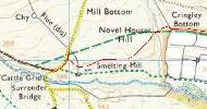
Around 0.4 miles from Cringley Bottom the track forks (there is a large sheep fold to the
left of the path) and the official route starts to descend. If you bear left
at this point then a good track (not marked on the maps but visible on Google
Earth) rejoins the official path without the need to descend and re-ascend.
(Red line on map below - click to enlarge).
In Arncliffe Wood
the public right of way, shown on maps, no longer exists as a path on the
ground. Simply follow the forest track up to the point where it meets the
Cleveland Way